
Scouting prioritization
Know which blocks or rows need a walk first instead of covering the whole property the same way.
Weekly scouting
Farmbit is built around one weekly question: which orchard, berry, or vineyard block deserves attention first, and what should the crew or advisor verify when they get there?
What Farmbit is replacing
Not another map drop
You should not need to interpret a fresh orthomosaic from scratch every week.
Not another software seat
Farmbit is meant to hand off the next field decision, not create another tool the crew or advisor has to babysit.
A weekly field triage
Results page, ranked zones, likely drivers, and next actions for the next walk or advisor visit.
Use cases
Know which blocks or rows need a walk first instead of covering the whole property the same way.
Turn weak field signals into clear water / wait / check follow-ups for the crew.
Hand the advisor or crew a short first-pass brief before anyone spends half the day chasing weak signals.
Field brief
Farmbit should leave the crew with a short, inspectable weekly scouting report instead of a pile of files.
The few blocks or zones that need attention this week.
Operational hypotheses such as irrigation, canopy, or surface-condition issues.
What to check today, where to go first, and what to hand off to the advisor.
Coverage, QA, and evidence notes so crews know what to trust.
Fit pages
These fit pages are not generic doorway pages. Each one explains what Farmbit helps catch early, where the signal is weak, and what a crew-ready brief should look like for that crop or role.
Use Farmbit to rank which almond blocks deserve the first walk, what the crew should verify first, and when a closer follow-up is worth paying for.
Rank vineyard blocks before the first walk, narrow where the crew should stand first, and decide when drone or phone follow-up is actually worth it.
Use Farmbit to narrow which berry blocks deserve the first walk, what the crew should verify first, and when closer follow-up is worth the cost.
Help the apple crew decide where to walk first, what likely changed, and when one block needs closer evidence than the free satellite pass can provide.
Open the advisor page when the question starts from the visit plan, the first stop, or whether one block deserves closer proof before the truck arrives.
Operating model
These pages explain the logic behind the product: close the loop from survey to action, start with workable RGB and multispectral inputs, and judge tools by whether they shorten the next field decision for the crew or advisor.
Survey
Use a repeatable flight or photo routine so the comparison next week still means something.
Analyze
Look for the few places that changed, not a perfect explanation for every pixel.
Decide
Turn the signal into a short list of blocks or zones worth checking first.
Act
The brief should say what to inspect when they arrive, not just that something looks off.
Verify
The second pass matters. That is where trust grows and false alarms start to fall away.
Workflow hub
The main workflow page explains why field teams stop trusting maps when the brief ends one step too early.
5 min read
RGB is enough to start a serious orchard scouting workflow when the team cares about ranking the walk, checking the likely cause, and verifying the result a few days later.
4 min read
Imagery helps, but it is still unfinished work until someone decides where to walk first, what to inspect, and whether last week's change actually helped.
Compare the alternatives
Comparison pages work best when they stay focused on the operational decision, not on a feature-table argument.
Satellite NDVI vs Farmbit
Satellite NDVI is useful for broad monitoring. Farmbit is the better fit when a small orchard crew needs a ranked walk order, a short report, and a direct brief this week.
DIY sensors vs managed system
A DIY stack is a hardware and maintenance project. Farmbit is the better fit when the team wants a managed workflow that resolves into one weekly field brief.
Drone mapping vs Farmbit
Drone mapping is the right closer proof step. Farmbit is the better fit when the team first needs to know whether one block deserves that extra spend.
Manual orchard scouting vs Farmbit
Manual scouting is still necessary. Farmbit makes it more focused by ranking the first walk and narrowing what the crew should verify first.
Problem pages
Problem pages work best when the question starts from irrigation, disease scouting, or another field pain instead of crop type.
Use Farmbit to narrow where irrigation stress may deserve the first walk, what the crew should verify on the ground, and when the coarse signal is too weak to over-read.
Farmbit should help narrow where to verify early disease risk first, not pretend a coarse pass can confirm disease on its own.
Field guides
These guides are written for orchard, berry, and vineyard operators plus advisors, not for generic ag-tech SEO.
6 min read
A short field guide to reading NDVI in vineyards without mistaking vigor patterns for diagnosis.
30 min read
A full guide on how to sequence satellite, drone, and ground-truth scouting for lower-cost field decisions and better yield protection.
10 min read
When drone mapping is worth the cost, what block-level detail it adds, and why pretty maps still need ground truth.
10 min read
Why phone and ground photos are the only honest action layer, and the costly mistakes growers make when they skip them.
9 min read
What Sentinel-2 can actually tell vineyard and berry operators, and where 10-meter pixels stop being trustworthy.
14 min read
An evidence-based decision framework for BC vineyard and berry scouting: satellite for triage, drone for delineation, and phone or ground checks for action confidence.
8 min read
Why one map, one flight, and one dashboard is the wrong operating model for BC vineyards and berry blocks.
7 min read
A practical checklist for ranking the first walk, briefing the crew fast, and deciding when one block needs closer proof.
7 min read
A practical guide for turning weak irrigation signals into water, wait, and check follow-up instead of another vague stress map.
6 min read
A field guide for deciding which rows deserve the first walk, what to verify on the ground, and what should stay low priority.
Public result proof
The sample run shows the kind of field triage an orchard, berry, or vineyard team can actually inspect.
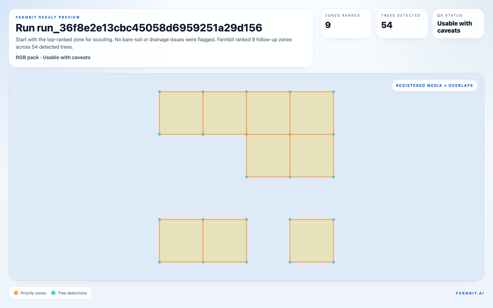
Result page
Open the same result page a crew lead would use before leaving the yard.
Crew brief
Read the short PDF that tells the crew what to verify on the ground.
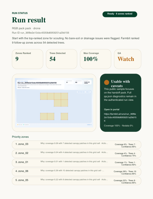
Preview image is for proof. Open the PDF for the full report pages.
Result page
Open the same result page a crew lead would use before leaving the yard.
Crew brief
Read the short PDF that tells the crew what to verify on the ground.
Priority map
Send the same scouting boundary to an advisor or GIS tool.
Next step
Run the free satellite block check, review the preview, and use that first read to decide whether this block needs a closer paid pass.